HuntStand -
您需要的唯一狩獵應用程序
Discover the all-new HuntStand app, now with a completely redesigned look and feel to enhance your scouting and navigation experience in the field. Recognized by Outdoor Life Magazine as the Best App for Hunters, HuntStand is North America's #1 Hunting & Land Management App, with over 6 million downloads. Whether you're searching for property lines, finding new hunting spots, or tracking deer movement, make HuntStand your go-to app for a successful hunting season.立即免費安裝!
►受歡迎的功能►
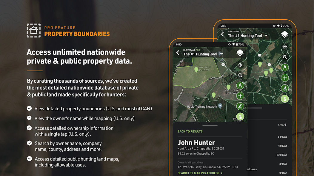
◆全國性財產線:訪問私人和公共財產邊界和全國50個州和加拿大大部分地區的公共土地地圖。
◆高級Whitetail預報:獨家15天的白尾尾活動預測預測,特定於您的確切位置。知道什麼時候打獵。
◆每月衛星圖像:每月交付新的衛星圖像,在狩獵場中查看變化。包括歷史檔案,上面有多年的圖像。
◆團體狩獵區:與夥伴,租賃合作夥伴和家庭共享狩獵區域。
◆全國車轍地圖:唯一的縣級白尾尾餐地圖,並通過顏色編碼的系統進行了可視化的綜合車轍日期。
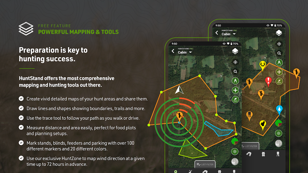
►免費開始映射►
Download HuntStand and start mapping your hunting areas today, completely free. Experience the value and power of HuntStand through these essential features.
◆GPS映射:查看您在地圖上的當前位置。實時移動時追踪您的路徑。添加地圖標記以節省重要位置,例如樹木架。
◆Huntzone Wind預測:繪製您的氣味影響與Huntzone,可在最多每小時的氣味預測中提前72小時提供。
◆狩獵區定制:設計狩獵區的詳細地圖,根據您的特定需求量身定制,並與狩獵夥伴,租賃合作夥伴和家人分享。
◆高分辨率衛星:查看狩獵區域的詳細,高分辨率的衛星圖像,以精確計劃和導航。
◆數字測距儀:新的測距儀模式允許在現場進行簡單的距離計算。
HuntStand
每年僅$ 29.99,享受可用的最具成本效益的狩獵應用程序。 Get all the great features of the HuntStand free hunting app plus the following nationwide hunting maps and features.
◆全國性財產線:訪問所有50個州和加拿大大部分地區的詳細屬性線圖。
◆財產所有權數據:查看所有50個州的全面財產所有權信息,並按名稱搜索財產所有人。
◆每月衛星圖像:使用新鮮的衛星圖像進行最新更新您的狩獵區的最新變化。包括歷史檔案。
◆公共狩獵地圖:探索各種公共狩獵土地。找到您的新熱點。
◆國家航空影像:全美國訪問高分辨率的航空影像
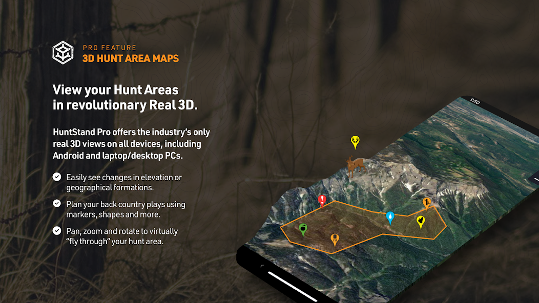
◆3D映射:在動態3D中導航並“飛行”您的狩獵地形,以增強計劃。
◆無限的離線地圖:保存您的狩獵地圖以供無網絡連接而使用。
► HuntStand Pro Whitetail ►
For the ultimate deer hunting experience, upgrade to HuntStand Pro Whitetail. Includes all HuntStand Pro features plus powerful tools made specifically for whitetail hunters.
◆ All HuntStand Pro Maps: Access all HuntStand Pro maps.
◆ All HuntStand Pro Features and Tools: Utilize all HuntStand Pro features and tools.
◆15天的白尾尾活動預測:查看峰值時間以狩獵和預測鹿運動,以精確的準確性。
◆年度Whitetail Rut地圖:在顏色編碼地圖(僅美國)上可視化縣級車轍數據。包括車轍的每個階段的車轍日期。
◆白尾棲息地圖:確定白尾鹿的最佳棲息地,以輕鬆找到新的狩獵區(僅美國)。
計費和訂閱:購買後,收費適用於您的Google Play帳戶。
隱私政策:https://huntstand.com/privacy
條款和條件:https://huntstand.com/terms-and-conditions