Mappy City - Transports Paris -
Mappy City (Beta Version) - Simplify your commute to Paris and IDF
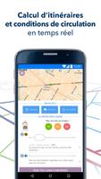
MappyCity allows you to calculate your routes to get around Paris and be informed in real time about traffic conditions.
• Journeys:
Discover the best routes in all modes of transport: metro, RER, tram, bus, Vélib', pedestrian, taxi.
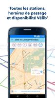
• Nearby stations:
Find on a map all the nearby public transport stations with the next passage times, and for the Vélib' the number of bikes and places available.
• Line plan:
Consult metro, RER, tram and bus maps.
• Favorites:
Save your favorite Vélib' lines and stations to keep up to date with disruptions and find workarounds in case of difficulties.
• Real-time traffic:
At a glance, MappyCity tells you the weather for each line:
- OK: it's green, everything is fine! There are no disturbances on the horizon
- BOF: it's orange, there are some slowdowns but nothing alarming
- KO: it’s red, it’s a disaster… There are major disruptions on the line
MappyCity is a community service. “Traffic” information is provided to you by the transport networks but also and above all by the community: you benefit from real-time information from other users, and you too can speak up to report problems.
Don't hesitate any longer and let yourself be guided all the way by MappyCity!
Do you want to share your impressions, questions, or good ideas with us? A little hello on: [email protected].
What's New in the Latest Version 2.0.17
Last updated on Jan 14, 2016 Here's a special Happy New Year update!For 2016 we wish the best for your travels:
- RER journeys without incident,
- metro journey without accordionists,
- Vélib' routes under the sun.
As we are not geniuses, but only geniuses, we can already:
- advise the best routes,
- indicate the number of places/bikes available at the terminals,
- provide traffic information in real time on the lines!
A question? [email protected]